At LANDMARC, we are developing methods and instruments that non-researchers can use to reliably estimate how different land-use practices contribute to climate change mitigation. In our view, this can only be done by bringing in local knowledge at every stage of the research process. Here’s why.

Using land to capture and store carbon dioxide is expected to become increasingly pivotal in future climate action and net zero strategies. As a result, it’s important for a wide range of people – from policymakers to business owners, farmers, foresters, and other land-users – to be able reliably estimate how much carbon different land-use practices capture and store. Reliable estimations can inform everything from individual farmers’ soil management practices, to national climate plans and international climate negotiations. That is why one of the things we’re doing at LANDMARC is developing methods and instruments that people can use to reliably estimate how different land-use practices contribute to climate change mitigation. In our view, this can only be done by bringing in local knowledge at every stage of the research process. Here’s why.
Why land-based mitigation matters
Land-based mitigation technologies and practices (LMTs for short) include a range of techniques for actively removing carbon dioxide from the atmosphere. They go beyond merely reducing greenhouse gas emissions by, say, restoring degraded ecosystems and swopping fossil fuels for more sustainable alternatives.
Net negative emission solutions are crucial for our net zero targets. This is because in sectors like heavy industry, electricity and transport, we are unlikely to be able to achieve net zero through emission reductions and clean energy alone. To reach the goals of the Paris Agreement, research, policy and markets are increasingly looking at technologies that can actively remove carbon dioxide from the atmosphere.
Many of these kinds of solutions are land-based. Land-based solutions include taking up carbon dioxide from the atmosphere via plants and storing it in vegetation biomass and soil organic matter. This can be done by planting forests (afforestation) or improved soil management in agriculture, for example. A more technology-oriented solution could be bioenergy with carbon capture and storage (BECCS). This approach combines generating electricity by burning biomass with carbon capture and storage technologies that store the carbon dioxide the burning releases in geological structures.
So our instruments need to be able to reliably estimate how much carbon could be captured and stored through these kinds of solutions. But, because of the central role that land plays in society, they also need to tackle a range of other important questions.
These include the feasibility and societal acceptance of specific land-use practices, trade-offs with other land-related goals such as food security and the protection of biodiversity, identifying suitable locations and combinations of LMTs, as well as their long-term effectiveness. Instruments that don’t answer these questions will be significantly less useful to policy-makers and land-users, who need to take multiple factors into consideration when making decisions about how to make the best use of land.
Scenarios and Simulation
To provide quality answer to these questions, LANDMARC applies a wide range of scientific methods. These range from field measurements of soil carbon content and satellite imagery for studying vegetation structure to scenario analysis and simulation models. It’s worth spending some time explaining what the scenario analysis and simulation modelling involves.
The goal of our scenario analyses is to explore the future prospects of land-based mitigation technologies in a transparent, reproducible and scientifically sound way. General speaking, a scenario is a plausible description of how the future may unfold. This should not be mistaken for a prediction.
To capture the large uncertainties involved, we start by identifying an LMT portfolio for a particular location. This is just a combination of different land-based mitigation practices that could work in that context. We then analyse a set of scenarios that, taken together, depict a wide range of potential future pathways that could lead to these LMT portfolios being realised there.
We start by describing these pathways in a qualitative format. That means as text, tables or in pictures. So, for example, we might start by describing how farmers in a particular region could combine afforestation and improved soil management of grazing land to increase net carbon uptake by soils and vegetation.
But because these practices can’t be viewed in isolation, we also describe the societal, political and economic boundary conditions that would need to be in place for people to be able to shift to those practices.
Once we have laid out our scenario, computer models come into play. We use these models to translate the qualitative descriptions laid out in the scenarios into numbers. (In other words, we quantify them.) The models we employ use mathematical approaches to simulate important processes like crop growth, carbon storage in vegetation and soils, land-use changes (the afforestation of a former grazing land for instance) and climate. Another thing we do with models is to adapt and couple them to create new methods and instruments which people can use to support decision-making when it comes to implementing our LMT portfolios – this is a particular focus on our project.
The simulation results help us to flesh out the scenarios and make them more specific. For example, simulations help us identify suitable locations for the land-use practices the scenario in question involves, the subsequent amount of carbon it would store, as well as by assessing potential conflicts with other land uses.
Stakeholder Engagement
Scenario analysis and model simulations like these are often conducted as academic desktop studies where the results are primarily intended to be read and used by other scientists doing similar research. In this respect, LANDMARC does things a little differently – both in how we develop scenarios, and in how we do the simulation exercises.
During both phases, the we work closely with people (both individuals and institutions) that are either directly affected by the practices in our LMT portfolios, or who would be responsible for their practical implementation if the scenarios came to pass. These might be the farmers and foresters who would need to adjust their land-management practices, or the policy makers that shape the respective regulatory frameworks. Engaging with people with that kind of on-the-ground expertise, helps us ask the ‘right’ questions and structure the scenario and simulation results so that they are useful for their decision-making. It also helps us assign better weighting to the real or perceived synergies and trade- offs associated with implementing our LMT portfolios.
Joining the dots – from local to global and back
So far, we have covered how models can help us to estimate what the effects of different reasonable scenarios would be. When combined with clear qualitative descriptions, these estimations provide valuable information that can support decision-making. We have also covered how engagement with land-managers, policy makers and others can help us more accurately explore the feasibility of our scenarios in both the short- and long-term. This is because this engagement gives us a better understanding of land-management best practices in that area and how acceptable the various LMTs would be to the people who would need to implement them.
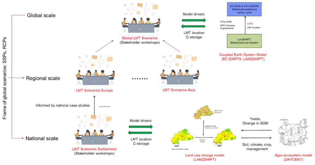
But it’s important to be clear that our scenarios and models do not only work at the local level. We also develop scenarios exploring what would happen if our LMT portfolios were adopted at a national, regional and global scale (see Figure).
The scenarios at each level are designed to address different questions in order to make them useful to a different group of people.
For example, our local level scenarios could help farmers decide what specific crops to plant. Our national level scenarios, on the other hand, generate information tailor-made for informing national climate plans. So when developing those scenarios, we engage with different kinds of stakeholders at each level, to make sure we get the context-specific knowledge we need for scenario building and modelling.
Another essential aspect of the LANDMARC framework is information exchange between different contexts. This means that our analyses of local-level scenarios will consider any LMT portfolios that are identified as important options in the national-level workshops. It also means that national-level scenarios will take into account and respect local scenarios. A similar logic is applied in the relationship between global, national and local scenarios and simulation studies. This approach ensures that higher levels don’t neglect variability on lower levels, which again might increase the local acceptance of policy measures by people that are directly affected.
Summing Up
By incorporating local knowledge throughout the research process, and by working at different scales, we are able to produce scenarios that are more realistic, in the sense that they are responsive to the particular combination of concerns, opportunities and limitations present in that particular location, country, or region. And by actually quantifying these scenarios through simulation modelling, we are able to generate accurate estimations of the mitigation potential of those realistic scenarios.
Putting all this together allows us to create the kinds of tools that can actually help people adopt the soil or forest management practices, policies, targets or international treaties that we need to bring those scenarios about.
LANDMARC
LANDMARC project
Negative emission solutions are expected to play a pivotal role in future climate actions and net zero emissions policy scenarios. To date most climate actions have focussed on phasing out fossil fuels and reducing greenhouse gas emissions in, for example, industry, electricity, and transport. While zero emission trajectories in these sectors will remain a priority for decades to come, it is expected that residual GHG emissions will remain. To be able to fulfil the Paris Agreement and meet the world’s climate goals research, policy and markets are increasingly looking at negative emission solutions.
This is why the nineteen LANDMARC consortium partners work together in order to: • Estimate the climate impact of land-based negative emission solutions, in agriculture, forestry, and other land-use sectors • Assess the potential for regional and global upscaling of negative emission solutions • Map their potential environmental, economic, and social co-benefits and trade-offs LANDMARC is an interdisciplinary consortium with expertise from ecology, engineering, climate sciences, global carbon cycle, soil sciences, satellite earth observation sciences, agronomy, economics, social sciences, and business. There is a balanced representation of partners from academia, SMEs, and NGOs from the EU, Africa, Asia and the Americas, which ensures a wide coverage of LMTs operating in different contexts (e.g. climates, land-use practices, socio-economic etc.) and spatial scales.Project details
- Project title: “LAND-use based MitigAtion for Resilient Climate pathways”
- Funding scheme: European Union Horizon 2020 Programme (EU H2020, Grant agreement ID: 869367)
- Duration: 4 years (1 July 2020 – 30 June 2024)
- Project coordinator: Technische Universiteit Delft, Dr. Jenny Lieu
- Project website: www.landmarc2020.eu