The Preliminary Risk Assessment desk survey was produced prior to soil investigations on the Lower Botanic Gardens (Belfast, UK). Planning records revealed little site development over the past 200 years, but identified multiple local historical industry-linked contaminant sources that could contribute to soil contamination. Community growers and site developers were considered most at risk from ingesting or inhaling any contaminated site soil dusts.
The Preliminary Risk Assessment was designed to identify the potential risk sources, pathways, and receptors for soil contaminants on the Lower Botanic Gardens, Belfast. This was achieved through desk-based research into the local current and past land usages, and subsequent potential historical or geogenic contaminant legacies. This investigation format adheres to the UK government LCRM Stage 1 risk assessment guidelines (Environment Agency, 2021a).
Currently, the site is an undeveloped turfed plot in the Lower Botanic Gardens public park, adjacent to the River Lagan, used by dog walkers, students, and the general public. There are no waste permits (DAERA, 2021a) or ecological considerations (DAERA, 2021b) on or near the site, though there are industrial discharge consents upstream on the river (DAERA, 2021c). Historically, the site has remained largely undeveloped since records began in 1832, with the exception of landfilling during the Stranmillis Embankment on the E border (1920s) and a row of post-war housing on the E border (1945-1971) (Department for Communities, 2011). The surrounding area is now largely residential, however there have been multiple potentially polluting past industries proximal to the site. These include local clay and brickworks, tramways route, bottle-works, and a bitumen factory (Figure 1).
Site geology comprises 300m-thick fine-medium grained Sherwood sandstone bedrock and overlying glaciofluvial till and boulder clays to the W, and tidal flat deposits to the E (Department for the Economy, 2020) (Figure 2). Kirk McClure Morton (2003) also identified made ground/infill surface substrates in a previous onsite investigation. Chemical analysis of previous borehole data reported high concentrations of lead, polycyclic aromatic hydrocarbons, petroleum hydrocarbons, acid soluble sulphides, and CO2 ground gas emissions (Kirk McClure Morton, 2003; Glover Site Investigations Ltd, 2008). The proximal River Lagan and underlying Sherwood Sandstone and alluvium aquifers are rated ‘poor quality’ and may also hold potential soil contaminants (Belfast City, 2020).
The combination of current and historical land uses and geological contaminant sources, possible pathways of contamination, and likely site users then indicate the potential for contaminant exposure and risk on the site. This is summarised in the conceptual site model. Here, inhalation of airborne particulate matter and released ground gases, and ingestion of soil particles or contaminated plant matter may pose the most significant risks onsite. Lesser risk is associated with dermal contact of site soils and plant matter, and very little risk is associated with ingestion, inhalation, and direct contact with contaminated soil dusts by offsite receptors; the influence of bedrock geological contaminants; and groundwater and surface water contaminant migration. Finally, it was concluded that further investigations will be required to establish the current distribution and concentrations of contaminants onsite in preparation for site development.
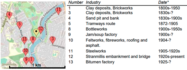
Figure 1: Proximal historical industrial locations (plot marked in yellow).
*Dates and locations are approximate due to incomplete records. Figure modified from Newell (2022).
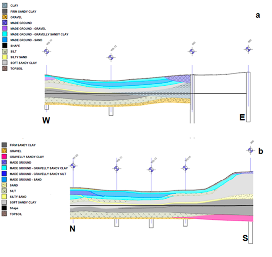
Figure 2: (a) W-E cross-section of geology underlying the site from borehole data (Kirk McClure Morton, 2003); (b) N-S cross-section of geology underlying the site from borehole data (Kirk McClure Morton, 2003) (Armstrong 2022). Taken from Newell (2022).
References
Armstrong, E. 2022. MEng student paper. Assessing the Risks posed by Land Contamination at Lower Botanic Gardens, Belfast. Queen’s University Belfast. Unpublished. (Accessed 21 May 2022)
Belfast City (2020) Local Development Plan 2020-2035. Available at: https://www.belfastcity.gov.uk/getmedia/d37dfcf8-f59e-428f-b558-71ae9a3abf37/POP024_TP-Env.pdf (Accessed 25 November 2021).
DAERA (2021a) Exemptions from Waste Management Licensing. Available at: https://public-registers.daera-ni.gov.uk/waste-exemptions (Accessed 22 November 2021).
DAERA (2021b) NIEA Natural Environment Map Viewer. Available at: https://appsd.daera-ni.gov.uk/nedmapviewer/ (Accessed 22 November 2021).
DAERA (2021c) NIEA WMU Water Information Requests Map Viewer. Available at: https://gis.daera-ni.gov.uk/arcgis/apps/webappviewer/index.html?id=7e234827aa7a405d990359aa92c7c287 (Accessed 22 November 2021).
Department for Communities (2011) Historic Building Details. Available at: https://apps.communities-ni.gov.uk/Buildings/buildview.aspx?id=9467&js=false (Accessed 23 November 2021).
Department for the Economy (2020) GSNI GoIndex. Available at: http://mapapps2.bgs.ac.uk/GSNI_Geoindex/home.html (Accessed 24 November 2021).
Environment Agency (2021a) Guidance: LCRM: Stage 1 risk assessment. Available at: https://www.gov.uk/government/publications/land-contamination-risk-management-lcrm/lcrm-stage-1- risk-assessment#tier-1-preliminary-risk-assessment (Accessed 22 November 2021).
Glover Site Investigations Ltd (2008a) Lyric Theatre Replacement, Ridgeway Street, Belfast. Lyric Theatre. Ref: 08-0272.
Kirk McClure Morton (2003) Contaminated Land Survey Final Report. Queen’s University Belfast. Ref: 5460.09/Reports.
Newell (2022) Preliminary Risk Assessment Lower Botanic Gardens, Belfast [Internal report]
UPSURGE
UPSURGE bridges the gap between the existing knowledge base on Nature Based Solutions and their step-by-step practical implementation for regenerative development of cities focusing on air pollution alleviation and climate neutrality.
Our main aim is to reroute cities and fast forward their regenerative transition benefiting from the potential of Nature Based Solutions (NBS).
UPSURGE is the response to the challenges faced by cities in their efforts to decrease the impacts of urban existence on climate change, mitigate air pollution and its health effects and reduce climate change stressors.
To help European cities enter the regenerative transition pathway, UPSURGE will provide an EU Urban Regenerative Lighthouse to serve as a reference framework and a reference network to accelerate, transfer and upscale the use of NBS and mainstream them into the agenda of urban policies through co-creation and co-design processes with citizens and other stakeholders.
UPSURGE will provide fit for problem NBS together with supportive digital, and governance solutions for urban space regeneration deployed and tested in 5 real-life demo cities in Europe.
Project details
- Project title: City-centered approach to catalyze nature-based solutions through the EU Regenerative Urban Lighthouse for pollution alleviation and regenerative development.
- Funding scheme: The project has received funding from the European Union’s Horizon 2020 under grant agreement No. 101003818
- Duration: 48 months (1 September 2021- 31 August 2025) extended to 28 February 2026
- Project coordinator: E-ZAVOD, ZAVOD ZA PROJEKTNO SVETOVANJE, RAZISKOVANJE IN RAZVOJ CELOVITIH RESITEV, Slovenia
- Project website: https://www.upsurge-project.eu